


MONROE Voting District, Perry County, Ohio
About
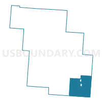
Outline

Summary
| Unique Area Identifier | 650919 |
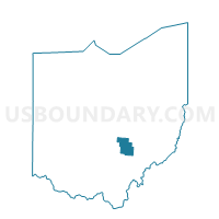
| Name | MONROE Voting District |
| County | Perry County |
| State | Ohio |
| Area (square miles) | 32.79 |
| Land Area (square miles) | 32.60 |
| Water Area (square miles) | 0.19 |
| % of Land Area | 99.43 |
| % of Water Area | 0.57 |
| Latitude of the Internal Point | 39.58762570 |
| Longtitude of the Internal Point | -82.08782050 |
Maps

Graphs
Select a template below for downloading or customizing gragh for MONROE Voting District, Perry County, Ohio


Neighbors
Neighoring Voting District (by Name) Neighboring Voting District on the Map
- BEARFIELD EAST Voting District, Perry County, OH
- COAL Voting District, Perry County, OH
- CORNING Voting District, Perry County, OH
- HEMLOCK Voting District, Perry County, OH
- PLEASANT Voting District, Perry County, OH
- PRECINCT HOMER/UNION, Morgan County, OH
- PRECINCT W.BLOOM/DEERFIELD, Morgan County, OH
- RENDVILLE Voting District, Perry County, OH
- SALTLICK Voting District, Perry County, OH
- Voting District TRIMBLE TOWNSHIP, Athens County, OH
Top 10 Neighboring County Subdivision (by Population) Neighboring County Subdivision on the Map
- Trimble township, Athens County, OH (4,480)
- Bearfield township, Perry County, OH (1,677)
- Monroe township, Perry County, OH (1,508)
- Salt Lick township, Perry County, OH (1,262)
- Homer township, Morgan County, OH (1,058)
- Coal township, Perry County, OH (1,042)
- Deerfield township, Morgan County, OH (927)
- Pleasant township, Perry County, OH (846)
- Union township, Morgan County, OH (614)
Top 10 Neighboring Place (by Population) Neighboring Place on the Map
Top 10 Neighboring Unified School District (by Population) Neighboring Unified School District on the Map
- Morgan Local School District, OH (14,178)
- Crooksville Exempted Village School District, OH (5,491)
- Southern Local School District, OH (4,814)
- Trimble Local School District, OH (4,621)
Top 10 Neighboring State Legislative District Lower Chamber (by Population) Neighboring State Legislative District Lower Chamber on the Map
Top 10 Neighboring State Legislative District Upper Chamber (by Population) Neighboring State Legislative District Upper Chamber on the Map
Top 10 Neighboring 111th Congressional District (by Population) Neighboring 111th Congressional District on the Map
Top 10 Neighboring Census Tract (by Population) Neighboring Census Tract on the Map
- Census Tract 9663, Perry County, OH (6,150)
- Census Tract 9661, Perry County, OH (4,607)
- Census Tract 9726, Athens County, OH (4,483)
- Census Tract 9690, Morgan County, OH (4,271)